Das
Pulvermaar
Das Pulvermaar liegt
südöstlich von Daun in Rheinland-Pfalz und gehört neben dem
Holzmaar zu den Gillenfelder Maaren. Das fast kreisförmige Maar hat
steile trichterförmige Wände. Mit einer maximalen Wassertiefe von
72m ist es das tiefste und mit einem Durchmesser von 700m eines der
größten und schönsten Maare der Vulkaneifel.
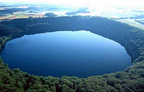
Es ist ein ringsum von
hohen Kraterwänden eingeschlossener Kessel mit einem Wasserspiegel
von über 36ha. Die Wassermenge beträgt bei einer Tiefe von
über 70m 13.170.000m3. Er bildet ein Musterbeispiel
eines Maarsees (im Gegensatz zu einem Trockenmaar). Das
oberirdische Einzugsgebiet ist sehr klein. Er wird durch die
Wasserscheide begrenzt, die beim Pulvermaar oben auf dem Kraterrand
liegt. Nach dem Bodensee und den Voralpenseen ist das Pulvermaar
der tiefste natürliche See Deutschlands. Die theoretische
Wassererneuerungszeit, also die Zeit, in der der gesamte
Wasserkörper durch zufließendes und abfließendes Wasser theoretisch
einmal ausgetauscht ist, beträgt beim Pulvermaar rund 70 Jahre.
Eingetragene Stoffe werden erst nach vielen Jahrzehnten wieder aus
dem See ausgeschwemmt. Zum Vergleich: die Wassererneuerungszeit vom
Tegernsee wird mit 1,25 Jahren angeführt.
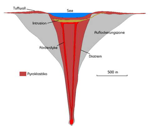
Die Bildung des
Pulvermaars wurde durch die vorhandene geologische Besonderheit
ermöglicht. Unterhalb der Erdkruste verbreitet sich das
aufsteigende heiße Material pilzförmig und beginnt das
Mantelgestein aufzuschmelzen. Begünstigt von Schwächezonen im
Erdmantel und dem Druck des dichteren umgebenden Gesteins finden
die Schmelzen durch Kanäle (Förderdyken) den Weg direkt an die
Oberfläche. Beim Pulvermaar gelangte das Lava zu den
grundwasserführenden Gesteinsschichten. Die aufsteigende Magma riss
durch die explosionsartige Druckzunahme beim Verdampfen des Wassers
auch umliegende Gesteine mit. Das herausgerissene Gestein bildet
den Schlot (Diatrem) unter dem Maar. Der Maarwall wird dabei aus
den Tuffen gebildet. Untersuchungen zeigen, dass sich unter dem
Pulvermaar ein Einschluss (Intrusion) in Form eines Lavasees
befindet.
Was aber
ist ein Maar?
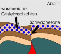
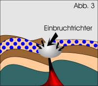
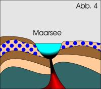
Ein Maar ist ein
schüssel- oder trichterförmiger Vulkan, der in die vorvulkanische
Landoberfläche eingesenkt ist. Durch Schwächezonen im Erdmantel
gelangt Magma in die oberen Gesteinsschichten (Abb.1). Durch eine
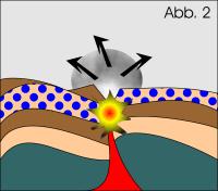
gewaltige Explosion, die durch das Aufeinandertreffen von
Oberflächenwasser und heißer Magma oder Lava hervorgerufen wird
(Abb.2), bildet sich ein Einbruchstrichter (Abb.3). Maare sind
kreisförmig oder oval, die Mulde kann flach oder trichterförmig
sein und man unterscheidet den wassergefüllten Maarsee (Abb.4) vom
Trockenmaar.
Logbedingungen:
1. Mache ein Photo von Dir und deinem
GPS vor dem "Pulvermaar". Von welcher Stelle aus Du das Bild
machst ist Deiner Kreativität überlassen. Eine mögliche Position
wäre vor der Terrasse bei N50° 07.928
E006° 55.797.
Parken könnt ihr z.B. bei N50°
08.012 E006° 55.695
2. Beantworte folgende Frage und sende
die Antwort an
team-poseidon@gmx.net:
- Warum fiel der Wasserstand des
"Pulvermaars" in den letzten 50 Jahren?
Es gibt mehrere Gründe, nenne einen oder
zwei von ihnen!
Achtung:
Bitte gebt keine Hinweise zu den Antworten in Eurem
Log!
(english)
The Pulvermaar lies
south-eastern from Daun at Rheinland-Pfalz and is beside the
Holzmaar a part of the Gillenfelder maars. The almost circle maar
has steep funnel-formed slopes. With a maximal waterdeep of 72m it
is the deepest and with a diamter of 700m it is the biggest and
most beautiful maar at the Vulkaneifel.
It is an all around,
by high craterwalls enclosed caldera, with a waterlevel about 36ha.
The water amount adds up to 13.170.000m3 by a waterdeep
of more than 70m. It builds an exemplar of a maar-lake (in
opposition to a dry maar). The overground catchment basin is very
small. The catchment basin is define by the watershed, which lies
above the crater boundary. Beside the Lake Constance and the lakes
at the foothills of the Alps, the Pulvermaar is the deepest natural
lake in germany. The time of the water renewal (time, in which the
waterbody is replaced completely by effluent water) represents at
the Pulvermaar about 70 years. Introduced substances will be first
leach aut of the maar in some decades. By comparison: the time of
the water renewal at the Tegernsee is calculated with 1,25
years.
The formation of the
Pulvermaar was rendered possible by the existing geological
charactersitic. Below the lithosphere, the ascending hot magma
begins to melt on the mantle of the earth. Because of structural
weakness of the lithosphere and the pressure of the surrounding
rocks the lava comes up to the surface througt passages, at the
Pulvermaar the lava ascended to the aquiferous thicknesses. The
magma bursted surrounding rocks because of the explosion, caused by
the increasing pressure and the evaporation groundwater. This torn
out material forms the funnel (diatrem) below the maar. The wall of
the maar is build of tuff. As many researches show, there is an
intrusion in form of a lake of lava beneath the maar.
But what is
a maar?
A maar is a broad,
low-relief volcanic crater embeds into a prevolcanic landscape. As
a result of structural weakness of the litosphere, the lava comes
up to the upper thicknesses (fig.1). By a phreatomagmatic eruption,
an explosion caused by groundwater coming into contact with hot
lava or magma (fig.2), a large caldere is formed (fig.3). Maars are
circular or oval, the basin can be plain or funnel-formed and a
distincion is drawn between the waterfilled maar-lakes (fig.4) and
those, who are dry.
To log the
cache:
1. Take a photo of you and your
gps in front of "Pulvermaar". E.g. at
N50° 07.928 E006°
55.797.
You can
park your car at N50° 08.012
E006° 55.695
2. Answer the following question and
sent the answer to
team-poseidon@gmx.net:
- Why did the waterlevel of the
Pulvermaar decrease in the last five decades?
There are several reasons - name one or
two of them.
Attention:
Please don't give hints to the answers in your log!